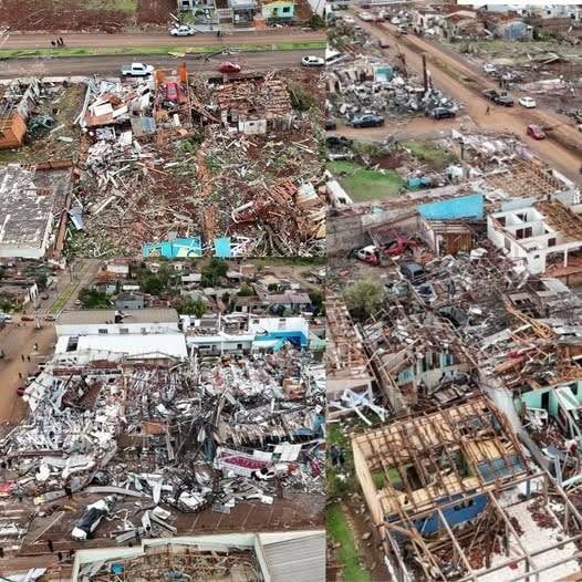
As we reported earlier, Melissa ranks as the most powerful hurricane ever to make a direct strike on Jamaica.
Across the broader Atlantic, however, Melissa stood out for several extraordinary reasons:
It matched the record for the strongest hurricane to make landfall anywhere in the Atlantic basin, with sustained winds reaching 185 mph.
With a central pressure of 892 mb, Melissa also equaled the 1935 Labor Day Hurricane as the most intense landfalling storm on record.
In addition, Hurricane Hunter aircraft — which collect vital data by flying directly into storms — recorded an instantaneous wind gust of 252 mph just above the ocean surface before Melissa made landfall.
For comparison, this reading falls only slightly below the world record for the highest wind gust ever documented in a tropical cyclone: 253 mph, observed during Cyclone Olivia’s impact on Western Australia in April 1996.
The account of Melissa brings together three different measurements: sustained wind, central pressure, and an instantaneous gust. They describe related aspects of a powerful storm, but they are not interchangeable. A sustained wind figure represents wind measured over a defined period, while a gust describes a shorter peak. Comparing them as though they were the same measurement can make an already extreme event harder to understand.
The reported pressure value serves another purpose. Central pressure helps describe the atmospheric structure of a hurricane and the intensity of its low-pressure center. A comparison with a historic storm can place that number in context, but the pressure alone does not describe every impact experienced along a coastline. Rainfall, the movement of water, the storm’s track, and the length of exposure also shape what communities face.
The aircraft observation is striking because it records conditions close to the ocean surface before landfall. Even so, an instantaneous reading from an aircraft should not be treated as identical to a surface observation at a fixed land station. The comparison with Cyclone Olivia emphasizes the scale of the reported gust, while the circumstances of each measurement remain relevant to how the figures are interpreted.
Historical comparisons can be useful without turning a storm into a competition of numbers. A hurricane’s place in a record book is one part of its story. For people in the affected area, the immediate significance is the force of the weather around them and the disruption it causes to ordinary life. The distinction keeps the discussion focused on the event rather than only on superlatives.
The wording also matters in time. The account describes Melissa’s landfall and observations made before it; it is not, by itself, a current forecast that a new storm is forming. A headline may continue circulating after the conditions it describes have passed. Readers should therefore separate a retrospective description from a live warning or a forecast for a particular location.
Together, the reported figures explain why Melissa attracted such attention in discussions of Atlantic hurricanes. The sustained wind, pressure, and aircraft gust each point to an exceptionally intense system in the account. Keeping the measurements distinct gives the comparison meaning and avoids suggesting that one dramatic number tells the entire story of the storm.